The Greater Köpenick Round Trip
Introduction
Berlin's waterways offer numerous possibilities for round trips by boat, whether including the Havel lakes in the west, the various canals in the greater Berlin area and/or the Spree in the city centre. To explore the waters in the south-east of Berlin, however, the Greater Köpenick Round Trip is the top choice.
Reimar Gilsenbach, elder statesman of the GDR environmental movement, promoted it with the following words:
"When a foreign head of state visits us, the magistrate puts the honoured guest on a luxury vessel of the White Fleet and takes him around the Müggel hills. Wouldn't you like to treat yourself to that pleasure too? Without the great tour you only know half of Berlin. It's worth it!"
(A short paean and reflection by a Berliner on the Müggelturm,
in Reimar Gilsenbach: Schönheit der Flüsse und Seen, Greifenverlag zu Rudolstadt, 1976)
The course of the Greater Köpenick Round Trip is sketched in Fig. 1 with a white dashed line. The arrows indicate the direction in which we undertake the great tour here and in which we will describe the waters and their stories, sights and curiosities (clockwise). Of course, one can also travel the Greater Köpenick Round Trip in the opposite direction; start and finish may be at any point on the route.
If the pier of the Bootswerft Sturzbecher at the junction of the Alter Spree and the Gosener Kanal (red circle in Fig. 1) is chosen as the start and end point for the direction of travel sketched in Fig. 1 for the Greater Köpenick Round Trip, the following sequence of water bodies is traversed:
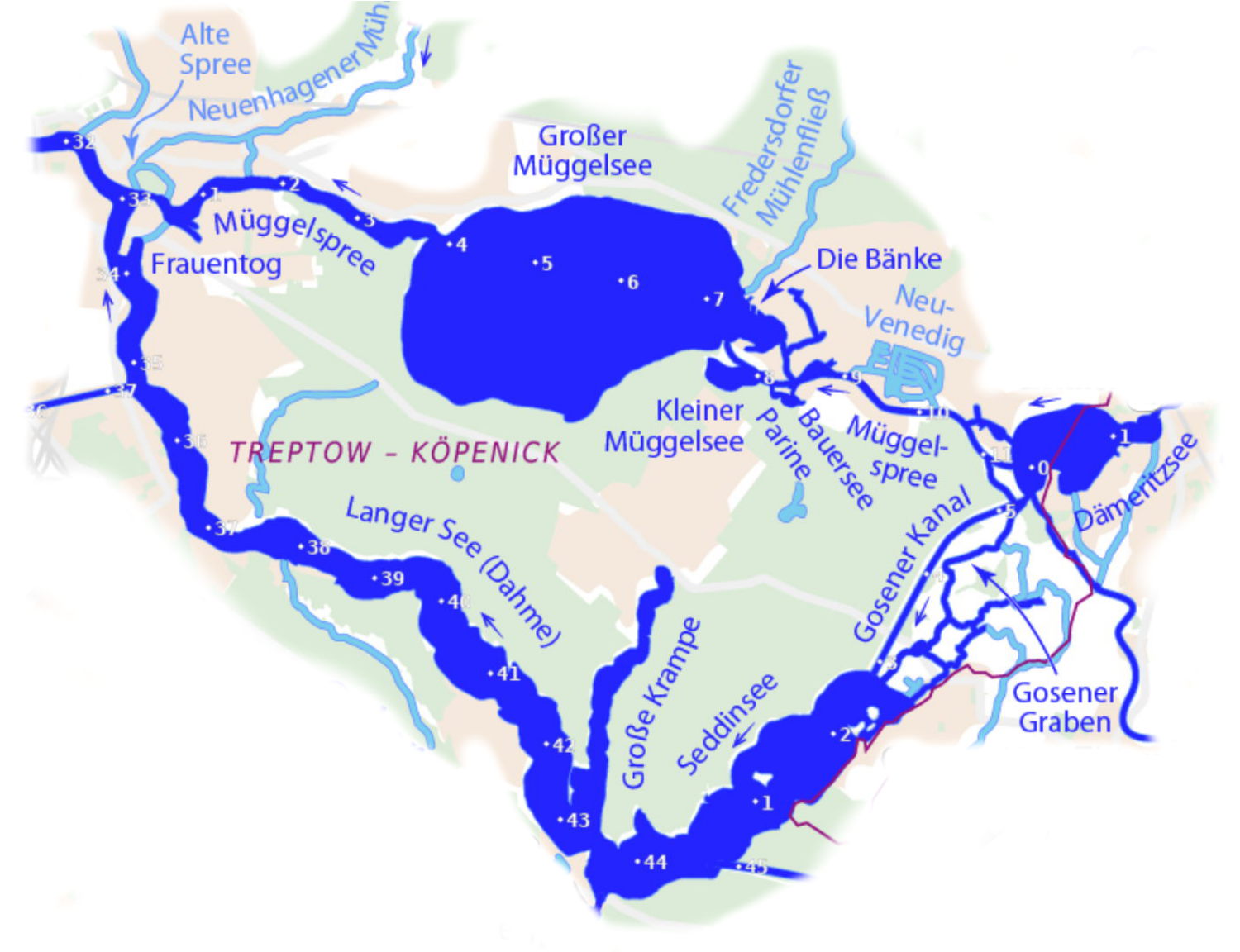
Gosener Kanal → Seddinsee → Langer See → Dahme → Müggelspree → Großer Müggelsee → Müggelspree → Kleiner Müggelsee → Müggelspree → Dämeritzsee → Gosener Kanal.
You follow the flow direction of the water bodies up to the mouth of the Dahme into the Spree in Köpenick, initially southwestwards, then northwestwards from Schmöckwitz. After entering the Müggelspree in Köpenick you travel eastwards or southeastwards and thus upstream.
The map above shows how the Greater Köpenick Round Trip is situated within the waterways of the Berlin region. The main flow direction of the water bodies is indicated by small blue arrows. The map also gives the kilometre markings of the waterways, which always run from the mouth to the source, i.e. against the flow direction (starting at km 0 at the mouth). For the Greater Köpenick Round Trip the information in Fig. 2 yields a voyage length of approx. 30 km. Since the permitted speed on the entire route – with the exception of Müggelsee – is limited to 8 km/h, the travel time with a motorboat is at least 3,5 h. With a canoe you should allow at least 6 h for normal paddling.